Combining machine learning and satellite imagery to address health and sustainability challenges
The scarcity of reliable data availability is major obstacle for monitoring and finding important health and sustainability information, especially in developing countries. On the other side, high-resolution satellite imagery is increasingly available and inexpensive. But, such remote sensing data is highly unstructured & noisy, and presently, there is no such technology available to automatically extract helpful information from this data. The research aims to combine machine learning with satellite imagery to answer significant health and sustainability challenges. For example, mapping global health indicators with remote sensing data, tracking changes in air quality worldwide, and tracking changes in air quality around the world. ( I have some fantastic research ideas, feel free to contact me if you are interested). Also, we will develop and deploy better machine learning algorithm that will automatically extract useful information from satellite data.
Some links to download satellite data: (1) https://developers.google.com/earth-engine/datasets ; (2) https://earthexplorer.usgs.gov/
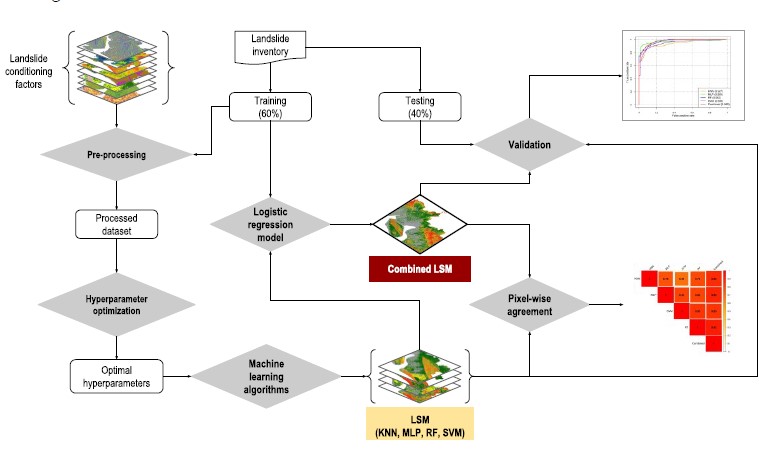
Improving spatial agreement in machine learning-based landslide susceptibility mapping
- Despite yielding considerable degrees of accuracy in landslide predictions, the outcomes of different landslide susceptibility models are prone to spatial disagreement; and therefore, uncertainties. Uncertainties in the results of various landslide susceptibility models create challenges in selecting the most suitable method to manage this complex natural phenomenon. This study aimed to propose an approach to reduce uncertainties in landslide prediction, diagnosing spatial agreement in machine learning-based landslide susceptibility maps. [Paper]